
Sorry folks. This isn’t a post about Mike and how much fun he had over Easter. Once again, I’ve ran in to that age old issue of “the computer is in one state and the camera (along with it's memory card) is in another”. And while I’m not sure that many of you often have this same problem – I’m sure that you can all relate…
Instead, this is a post about water. Lots and lots of water. Not quite record breaking (at least not yet – let’s hope it stays that way) – but its at least epic in proportion.
You see – a few weeks ago here in southern Indiana (once upon a time we used to call it “sunny southern Indiana” – but it lost that title some time ago) it started raining. And it’s rained and rained and rained. For days and days and days. And I’m not talking about the “Seattle style drizzle”. No sir. I’m talking about several inches per day (along with a tornado or two per week).
And the epic part? The flooding. I stopped by some of my childhood stomping grounds – the park by the Newburgh Lock and Dam. Ahh – the days of playing Lazar Tag at that park. But I digress…
I’m sure that not all of you are from a river town. A quick course on the “lock and dam”…
Most folks know that a dam is a solid structure that holds back the water. In this particular case, it’s concrete “weir” on the south side of the river with “Tainter gates”, located in the middle of the lock-n-dam structure. The gates control the upstream and downstream water level while the weir is the overflow spillway. Raising the gates lowers the upstream level and raises the downstream level. Lowering the gates causes the opposite. The “lock” part of the lock-n-dam (on the north side of the river in this case) allow all river traffic to pass from one side of the dam to the other. For example – a barge enters the lock on the upstream side. The lock doors are closed, and the water level is lowered to match the downstream side. The exit doors are opened and the boat steams away. It works remarkably well – and when a series of “lock-n-dams” are placed along the length of the river, water flow can be controlled very well – preventing droughts and floods. Unless…….
Well – every lock and dam has a maximum capacity. Once the water level is higher than the “dam” portion of the lock and dam then the water simply flows over the top and you can no longer control the depth. This is currently the situation for most of the dams along the second half of the Ohio River.
Normally, this isn’t too big of a deal. The walls that make up the lanes of the lock are significantly higher than the dam so river traffic isn’t affected. Low lying areas around the banks of the river begin to flood, but that isn’t all that unusual.
But every once in a while, it continues to rain and the river continues to rise. In Newburgh, the “flood stage” is 38 feet. This is when minor flooding in the low lying areas begins to happen. At 46 feet, some primary highways and secondary roads begin to flood. The current reading is 48.2 feet – the seventh highest level since things like this have been recorded (somewhere back in the late 1800’s). And if anybody is an Evansville history buff – you’ve heard of the “ ’37 flood” – the highest on record at 56.6 feet. Or possibly the more recent “ ’97 flood” which crested at 50.5 feet.
And right now, I can hear the thunder of the next approaching storm – predicting another 2 to 5 inches of rainfall with this one… So – if anyone has plans for an arc, please let me know. I’d like to begin construction right away…

The Ohio River at US HWY 41 between Evansville Indiana and Henderson Kentucky. The tree line is the southern bank of the river.
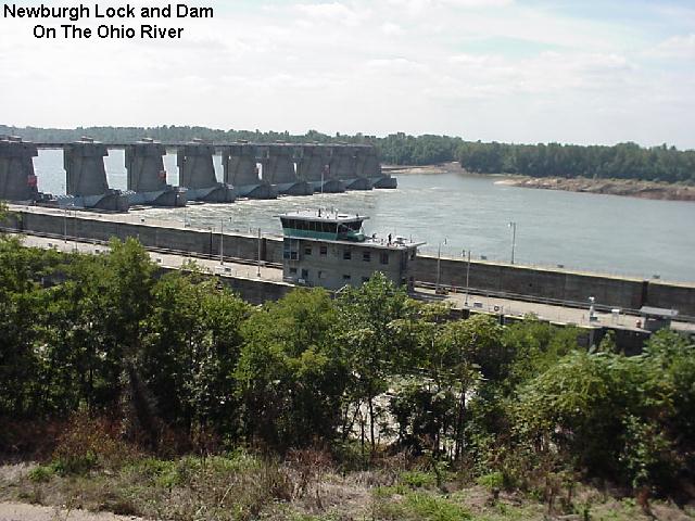
An “unflooded” picture of the Newburgh Lock and Dam. You can see the nine large “Tainter gates”in the middle (notice they are lowered in the water to control the upstream and downstream levels) and the “weir” to the right of them. The “locks” are in the foreground of the photo. You can see the tall walls that make up the lanes with the control house sitting in the middle.

A “flooded” picture of the Newburg Lock and Dam. You can see that the gates are raised up completely out of the water and the weir is completely underwater. You can also see that the walls that make up the lanes for the lock are nearly under water.

You can’t hardly see it – but the sign on the control house reads “47.1”. That’s 47.1 feet deep as of yesterday. It’s up to 48.2 today.

1 comment:
Bryon, be glad to give you plans for an arc, but wouldn't an ark be better with all the water?
Post a Comment